听力原文:Narrator Listen to part of a lecture about GPS. Professor What is GPS? Its full name is the Global Positioning System and a satellite-based navigation system. Generally speaking, it is made up of a network of 24 satellites placed into orbit by the U. S. Department of Defense. GPS was originally intended for military applications, but in the 1980s, the government made the system available for civilian use. Nowadays, GPS works in any weather conditions, anywhere in the world, 24 hours a day. There are no subscription fees or setup charges to use GPS. How does it work? At first, GPS satellites circle the earth twice a day in a very precise orbit and transmit signal information to earth. Secondly, GPS receivers take this information and use triangulation to calculate the users exact location. Essentially, the GPS receiver compares two times; one is the time a signal was transmitted by a satellite; the other is the time it was received. The time difference tells the GPS receiver how far away the satellite is. Now, with distance measurements from a few more satellites, the receiver can determine the users position and display it on the units electronic map. A GPS receiver must be locked on to the signal of at least three satellites to calculate a 2D position and track movement. With four or more satellites in view, the receiver can determine the users 3D position, here three dimensions are latitude, longitude and altitude. Once the users position has been determined, the GPS unit can calculate other information, such as speed, bearing, track, trip distance, distance to destination, sunrise and sunset time and more. How accurate is GPS? Todays GPS receivers are extremely accurate, thanks to their parallel multi-channel design. Garmins 12 parallel channel receivers are quick to lock onto satellites when first turned on and they maintain strong locks, even in dense foliage or urban settings with tall buildings. Certain atmospheric factors and other sources of error can affect the accuracy of GPS receivers. Garmin GPS receivers are accurate to within 15 meters on average. How about the Newer Garmin GPS receivers? With WAAS, that is Wide Area Augmentation System, its capability can improve accuracy to less than three meters on average. No additional equipment or fees are required to take advantage of WAAS. Users can also get better accuracy with Differential GPS, which corrects GPS signals to within an average of three to five meters. The U. S. Coast Guard operates the most common DGPS correction service. This system consists of a network of towers that receive GPS signals and transmit a corrected signal by beacon transmitters. In order to get the corrected signal, users must have a differential beacon receiver and beacon antenna in addition to their GPS. GPS satellites are powered by solar energy. They have backup batteries onboard to keep them running in the event of a solar eclipse, when theres no solar power. Small rocket boosters on each satellite keep them flying in the correct path. Here are some other interesting facts about the GPS satellites, also called NAVSTAR by the official of U. S. Department of Defense; the first GPS satellite was launched in 1978; a full constellation of 24 satellites was achieved in 1994; each satellite is built to last about 10 years. Replacements are constantly being built and launched into orbit; A GPS satellite weighs approximately 2 000 pounds and is about 17 feet across with the solar panels extended; transmitter power is only 50 watts or less. Now get ready to answer the questions. You may use your notes to help you answer. 18. What aspect of GPS does the talk mainly discuss? 19. What can be inferred about the present GPS functions? 20. According to the speaker, how accurate is a Garmin GPS receiver? Listen again to part of the lecture. Then answer the question. Professor A GPS receiver must be locked on to the signal of at least three satellites to calculate a 2D position and track movement. With four or more satellites in view, the receiver can determine the users 3D position. 21. What does the professor imply when he says this? Professor With four or more satellites in view, the receiver can determine the users 3D position(latitude, longitude and altitude). 22. What does the professor mean when he says this? Professor Once the users position has been determined, the GPS unit can calculate other information, such as speed, bearing, track, trip distance, distance to destination, sunrise and sunset time and more. 23. What can be inferred about the use of GPS nowadays?Narrator Listen to part of a lecture about GPS. Now get ready to answer the questions. You may use your notes to help you answer.
What aspect of GPS does the talk mainly discuss?
A.What it is made up of and its shortcomings
B.How it works and its attributes.
C.The history of its development.
D.How it is different from other technologies
 题目内容
(请给出正确答案)
题目内容
(请给出正确答案)

 如搜索结果不匹配,请

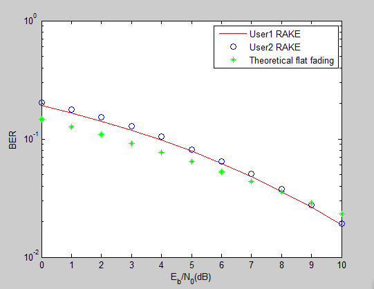
 , and is assumed to change from 0 dB to 10 dB with step 1 dB. The simulation results should be compared with the theoretical BER versus SNR curve in flat Rayleigh fading channel.